Google Earth is one of the most popular and essential programs used for various applications, including educational, governmental, and real estate activities. Its concept revolves around collecting images from diverse sources, ranging from low-resolution satellite imagery at high altitudes—reaching tens of thousands of kilometers above Earth’s surface—to closer satellites providing high-resolution photos, as well as aerial images captured by planes, drones, or even balloons. These images are made accessible to anyone who downloads the program on their phone or computer.
Through Google Earth’s scanning of the Earth’s surface, several peculiar locations have been noted, sparking much curiosity and speculation about their nature. This article explores some of these intriguing spots.
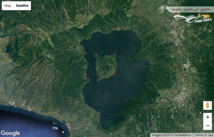
1. Island in a Lake on an Island in a Lake on an Island – Philippines
Google Earth captured an image of a lake within the caldera of a volcano, surrounded by an island named “Volcano Island,” which is itself encircled by a lake called “Taal” on Luzon Island in the Philippines. For years, this image was considered one of the most remarkable captured by the program until a new location in northern Canada took its place.
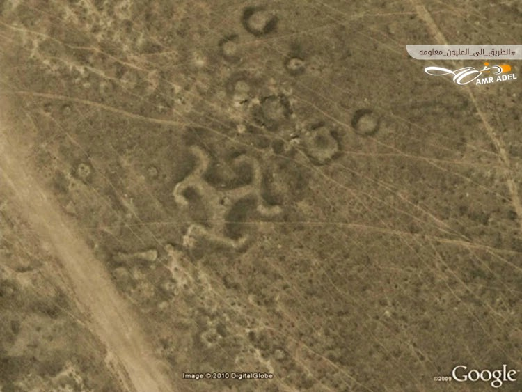
2. Swastika-shaped Patterns – Kazakhstan
During a Google Earth tour, scientists discovered over 50 geographical patterns in northern Kazakhstan, Central Asia, including a swastika-shaped design. Although constructed from wood, many surrounding patterns were made from earthen mounds. Scientists estimated these patterns to be about 2,000 years old, a time when swastikas were not widely used in Europe or Asia, nor associated with any political beliefs.
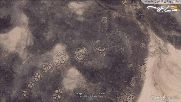
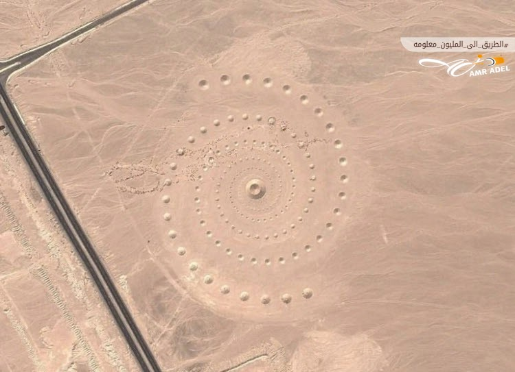
3. Mysterious Wheels – Jordan
The program captured structures resembling wheels, believed to date back around 8,500 years, making them older than the Nazca Lines in Peru. These wheels are spread across the Azraq Oasis in Jordan and are aligned with the sunrise during the winter solstice. A team of scientists investigated these structures using available satellite images and found varying shapes: some with lines radiating from their centers, while others were non-circular, resembling squares, rectangles, or triangles.
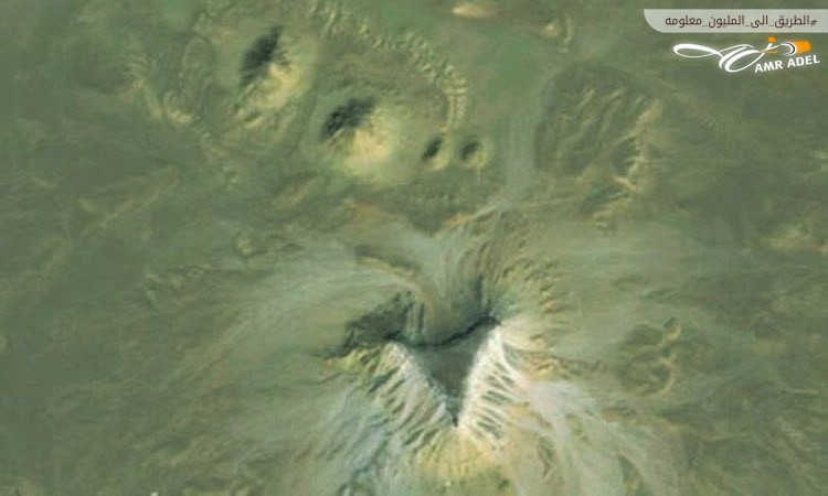
4. Mysterious Pyramid – Egypt
Google Earth images over Egypt revealed a mysterious formation thought to be an uncarved pyramid. This discovery has stirred debate about whether the formation is a natural occurrence or an artificial structure similar to the pyramids. Unfortunately, there is no definitive way to resolve this matter without physically visiting and excavating the site.
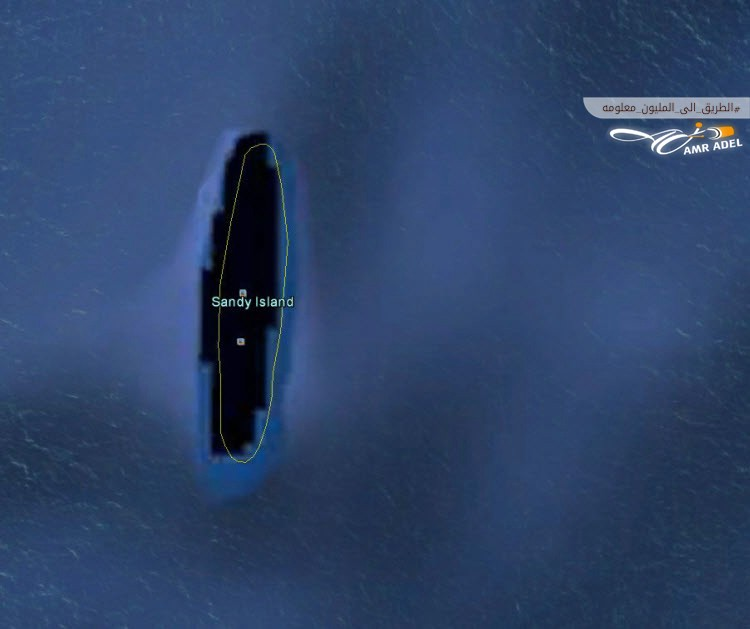
5. Phantom Island – Australia
A century ago, maps depicted an island the size of Manhattan in the South Pacific, northwest of New Caledonia, named “Sandy Island.” Google Earth, however, showed a different image of this location—a black polygon in the ocean. When scientists visited in 2012, they found open water instead of solid land. The island’s appearance on maps is thought to be due to a human error or volcanic debris accumulation that created a misleading impression of an island.
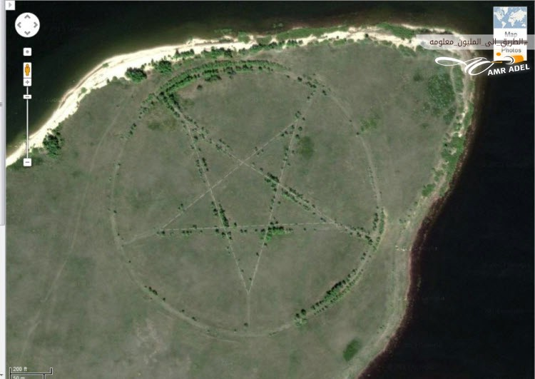
6. Mysterious Pentagon – Kazakhstan
In a remote area of Kazakhstan, a large five-pointed star with a diameter of approximately 366 meters is etched into the ground and surrounded by a circle. This star is clearly visible on Google Earth. Internet discussions have linked this image to satanic rituals or a subterranean religious group, but it was later revealed to be part of a park design in the shape of a pentagram, with the star’s edges representing tree-lined pathways.
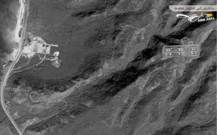
7. Abandoned Missile Sites – Hawaii
In the mid-1950s to the 1970s, the United States maintained surface-to-air missiles, some with nuclear warheads, ready to launch from 300 sites across the country. One such site, the “Oahu” defensive area in Hawaii, was once equipped with missiles aimed at Soviet territory. Professor David Toksbury, a GIS specialist in New York, aims to preserve a visual record of these abandoned sites before they are either obscured by natural processes or repurposed by the military.
8. Desert Breath – Egypt
This design, visible on Google Earth in Egypt’s Eastern Desert, may prompt thoughts of a gateway, cryptic message, or memorial to a mysterious creature. However, upon investigation, it was found to be an artistic installation called “Desert Breath,” created by artists Dana Stratos, Alexandra Stratos, and Stella Constantinidis in March 2007. Spanning 100,000 square meters, it celebrates the desert as a mental state and a pleasing natural landscape.
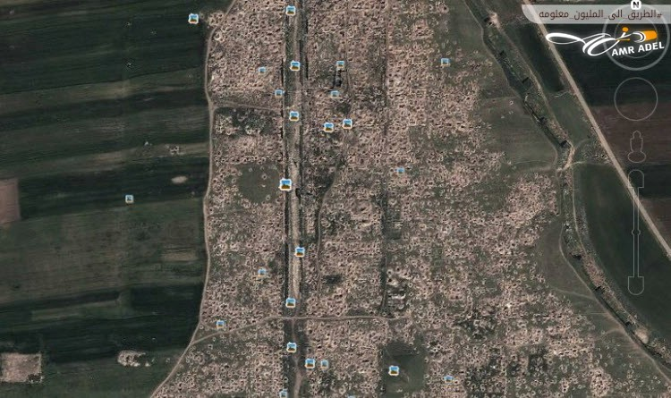
9. Ancient Roman City with Holes – Syria
During the Syrian Civil War, many archaeological sites were endangered, including UNESCO World Heritage sites. Satellite images from Google Earth revealed an ancient Roman city covered in holes dug by looters seeking artifacts. These holes make the site appear like the surface of the moon.
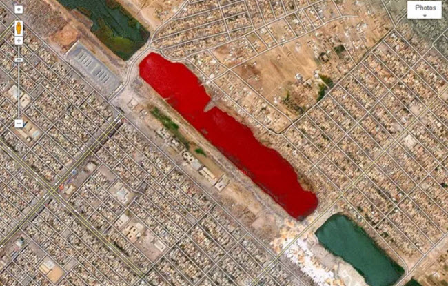
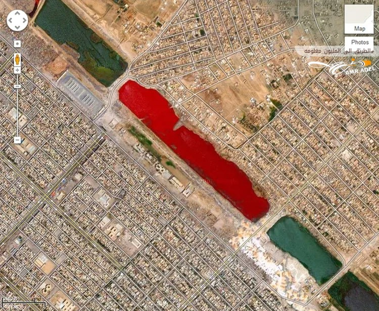
10. Blood Lake – Iraq
Using Google Earth to explore Sadr City in Iraq, one can observe a striking red lake, resembling blood. The scientific explanation for this phenomenon remains elusive.
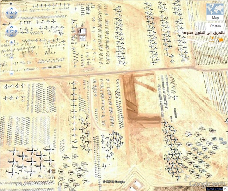
11. The Boneyard – United States
Davis-Monthan Air Force Base in Tucson, Arizona, serves as a final resting place for American military aircraft. This 2,600-acre “boneyard” is closed to the public but is visible in high detail on Google Earth, showcasing nearly every aircraft used by the U.S. military since World War II that has been retired from service.
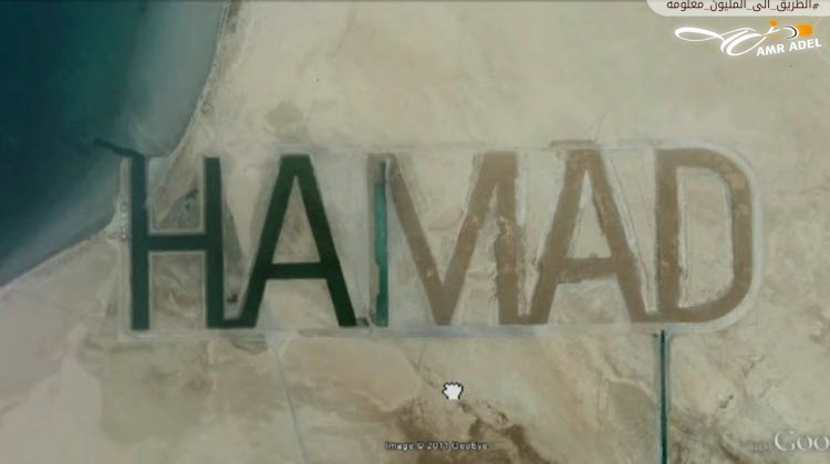
12. Sheikh Hamad’s Name – United Arab Emirates
Considered by some to be the largest name in the world, this inscription belongs to Sheikh Hamad bin Hamdan Al Nahyan of Abu Dhabi. His name is etched into the sandy surface of Al Fathiya Island in the Arabian Gulf, measuring half a mile wide and two miles long. The name is notable for its water channels, with the Gulf’s waters flowing through during high tides, partially filling the letter “M” in the image.
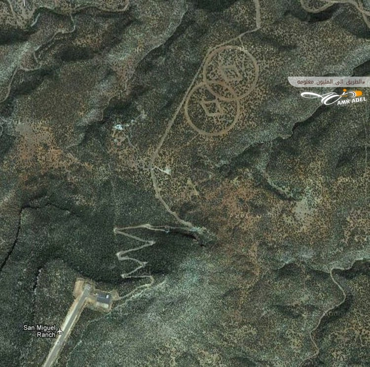
13. Stranger’s Hideout – United States
Found in the desert near Mesa Horvenita, New Mexico, this site features two masts surrounded by intersecting circles. Author John Sweeney claimed this site was a hidden bunker for the Church of Scientology. The church describes itself as a religion offering a precise path to understanding the spiritual nature of individuals and their connections with themselves, their families, their communities, humanity, and all life forms. Some reports suggest that such symbols help guide scientists who allegedly escaped Earth during an apocalyptic event and planned to return. However, these symbols remain an unresolved mystery.
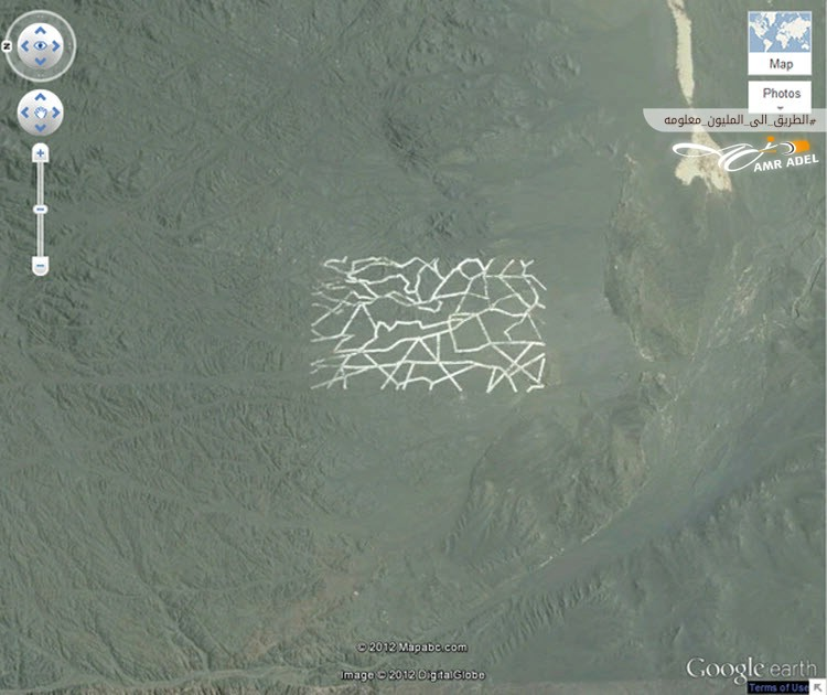
14. Gobi Desert – China
Google Earth images of the Gobi Desert in China revealed mysterious structures and shapes carved into its surface. Some experts suggest this site is a secret military base, with the structures serving various purposes such as weapon testing, satellite surveillance, and radar device testing.
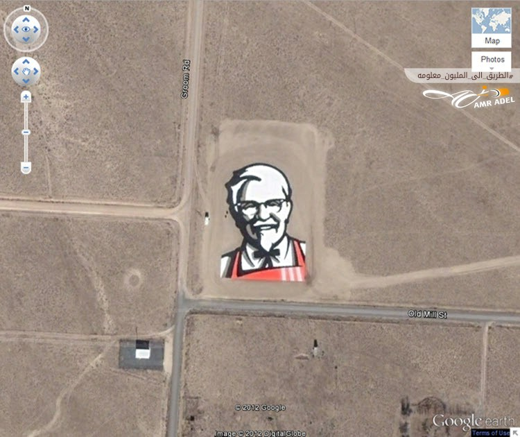
15. Kentucky Fried Chicken Logo – United States
With the rise of Google Earth and its widespread use, companies began launching advertising campaigns to feature their products on these maps. Kentucky Fried Chicken (KFC) created a large logo visible from space on a hillside in Nevada. Other companies have followed suit, with Coca-Cola constructing the largest logo on a Chilean hill, made from 70,000 empty Coke bottles.
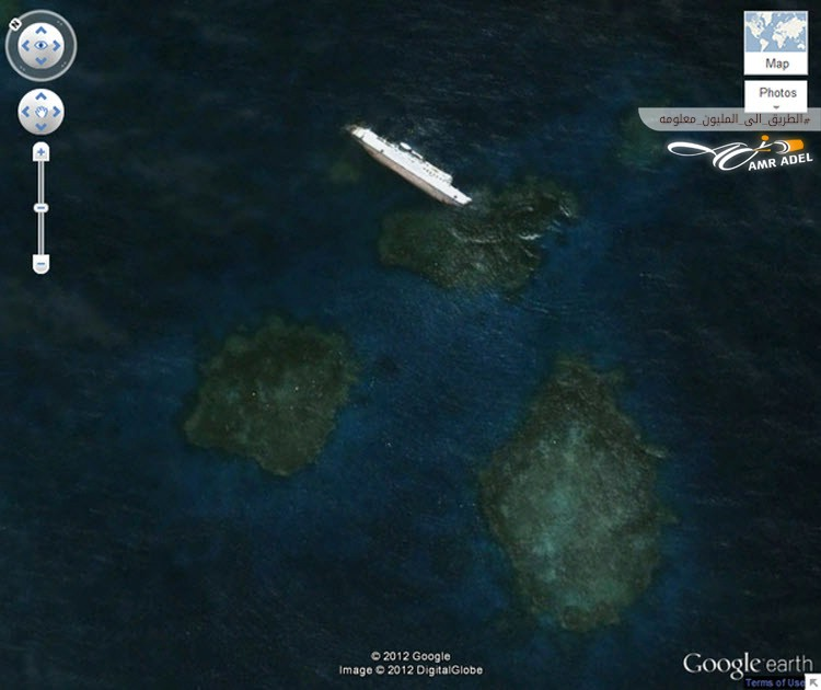
16. Large Shipwreck – Sudan
In 2003, a Bolivian cargo ship named “SS Gassim,” measuring 81 meters long, ran aground off the coast of Sudan and sank. Its wreckage, now one of the largest visible shipwrecks on Google Earth, is a notable sight.
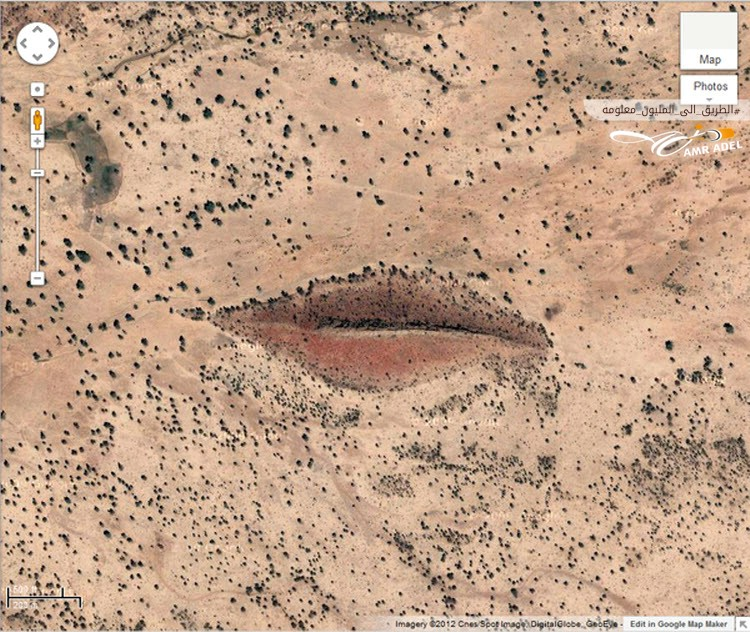
17. Open Lips – Sudan
Using the program to explore western Sudan, specifically Darfur, reveals a formation resembling human lips in a striking and impressive manner.
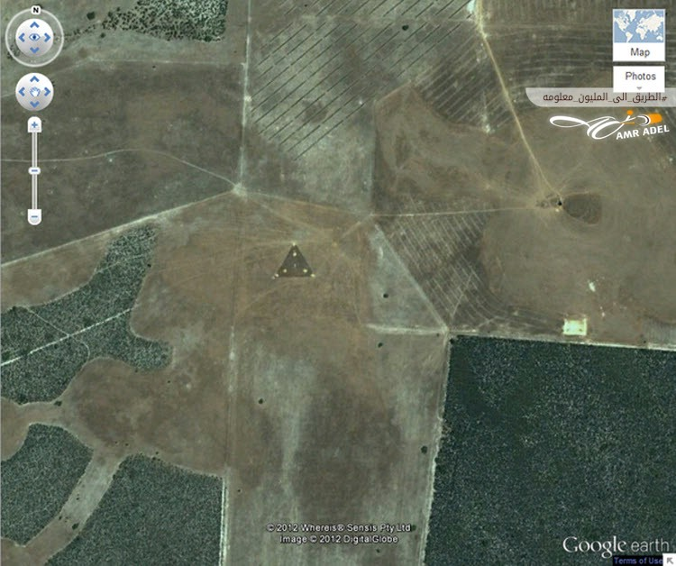
18. UFO-shaped Triangle – Australia
In Australia, a triangular pattern dotted with bright lights appears in the middle of a field, first discovered in 2007. Ophthalmologists quickly dubbed it the “UFO Triangle.” Google Earth users speculate it might be related to a nearby wind farm, constructed from three groups of wires forming a triangle with a central tower, potentially responsible for transmitting and receiving control signals.
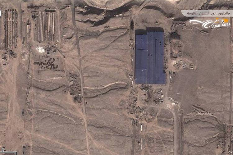
19. Secret Military Base – China
A set of mysterious satellite images on Google Earth created a buzz when a former CIA analyst claimed to have discovered building structures in the desert around Kashgar, a remote city in China’s Xinjiang Province. Some speculated these buildings were part of a secret military base. However, further analysis by Stefan Gens, a geographer who spent months in the region, suggested the site is likely part of an industrial or economic center.