
Tropical cyclones are intense circular storms that originate over warm tropical oceans, drawing their energy from the sea surface. They maintain their strength as long as they remain over warm waters and under low atmospheric pressure, generating winds that exceed 119 km/h. In extreme cases, wind speeds can surpass 240 km/h and occasionally reach up to 320 km/h. Tropical cyclones are accompanied by strong winds, heavy rainfall, destructive storms, and significant sea-level rises, which can be up to 6 meters above normal levels. Due to the fierce winds and powerful waves associated with these phenomena, tropical cyclones pose a significant threat to coastal areas in the tropical and subtropical regions of the world during the summer months, from July to September in the Northern Hemisphere and from January to March in the Southern Hemisphere. Cyclones commonly impact diverse regions such as the Gulf Coast in North America, Northwestern Australia, Eastern India, and Bangladesh.
Cyclones are named based on their geographic location. In the North Atlantic and Eastern North Pacific, they are called “hurricanes.” In the Western North Pacific around the Philippines, Japan, and China, they are referred to as “typhoons.” In the South-Western Pacific and the Indian Ocean, they are known as “tropical cyclones,” “cyclones,” or simply “spiral storms.” Despite the different names, these terms all refer to the same type of storm.
Formation of Tropical Cyclones
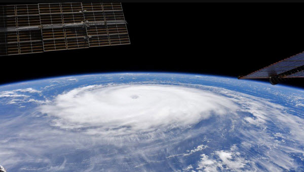
Tropical cyclones are fundamentally circular storms with a diameter of about 320 kilometers. Their winds revolve around a central area of low atmospheric pressure. The winds are driven by the low-pressure center, and due to the Earth’s rotation, the cyclone’s path is deflected by a phenomenon known as the Coriolis effect, which causes cyclones to rotate clockwise in the Southern Hemisphere and counterclockwise in the Northern Hemisphere.
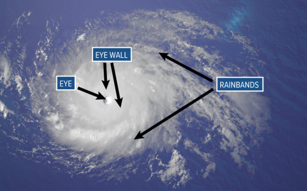
The wind field of a tropical cyclone can be divided into three areas. The outer region, or the outer ring, typically extends about 160 km from the center, with an inner radius ranging between 30 to 50 km. In this zone, wind speeds increase steadily towards the center and peak in the second region, the eye wall, which is usually 15 to 30 km from the storm center. Surrounding the eye wall is the eye, a central area where wind speeds significantly drop and the air is generally calm.
The Eye
The eye is a distinctive feature of cyclones, characterized by clear skies, warm temperatures, and low atmospheric pressure. While the normal atmospheric pressure at the Earth’s surface is about 1000 millibars, within the eye of a cyclone, it is typically around 960 millibars. In extremely powerful storms in the Western Pacific, this pressure can drop to as low as 880 millibars. The low pressure at the center results in a rapid pressure gradient, which contributes to the strong winds in the eye wall. The temperature in the eye of a tropical cyclone is about 5.5°C warmer than in surrounding areas. Since warmer air holds more moisture, the eye is generally free of clouds.
The Eye Wall
The eye wall is considered the most dangerous part of a tropical cyclone due to its destructive capabilities. In this region, winds are the strongest, rainfall is heaviest, and towering cumulonimbus clouds rise up to 15,000 meters. The eye wall’s winds reach their maximum speeds at around 300 meters above the surface, slowing closer to the ground due to friction. This area contains the highest vertical wind speeds, ranging from 5 to 10 meters per second (18 to 36 km/h). Though these speeds are lower than horizontal wind speeds, they are crucial for forming the towering clouds in the eye wall, which produce heavy rainfall.
Rain Bands
Cyclones often feature secondary cells organized into bands around the center, known as rain bands. These bands rotate around the storm’s core and can either remain stationary relative to the moving storm center or appear to rotate around it.
Lifecycle of Tropical Cyclones
The formation of tropical cyclones involves a series of stages. It begins with a tropical disturbance, usually marked by disorganized cloud buildup. As cloud speeds increase to 36 km/h, it becomes a tropical depression. If the cloud intensification continues and wind speeds exceed 63 km/h, it becomes a tropical storm. Once wind speeds surpass 119 km/h, the storm is classified as a tropical cyclone. Six conditions must be met for cyclones to form:
- The sea surface temperature must be 26.5°C or higher, and the depth of this warm layer must be at least 50 meters.
- There must be pre-existing atmospheric rotation near the warm surface layer.
- The atmosphere must cool rapidly with height to support the formation of deep convective clouds.
- The middle atmosphere should be relatively moist, around 5000 meters above the surface.
- The cyclone system must be at least 500 kilometers away from the equator.
- Wind speed must change slowly with height across the troposphere, not exceeding 10 meters per second between the surface and around 10,000 meters.
Tropical cyclones are fueled by the transfer of moisture and heat from the warm ocean to the overlying air through evaporation. As the warm, moist air rises, it cools and condenses, releasing latent heat. This process warms and moistens the air column at the storm’s core, promoting further ascent. The difference in temperature between the warm rising air and the cooler surrounding environment enhances vertical movement. If warm, moist air flows into an existing disturbance, further development occurs. As the warm air ascends, the pressure at the cyclone’s center decreases, leading to stronger surface winds, increased moisture and heat transfer, and a self-reinforcing cycle of intensification.
Impact of Tropical Cyclones
Horizontal Winds
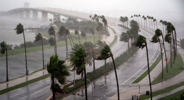
The intense winds associated with tropical cyclones can cause devastating damage. In severe cyclones, sustained winds can reach 240 km/h and exceed 320 km/h. The duration of intense winds at a particular location depends on the storm’s size and movement speed, which can last several hours. During this time, even the most robust buildings may suffer damage. Wind strength increases with speed: winds at 100 km/h exert a pressure of 718 Pascals, while winds at 200 km/h can increase this pressure fivefold to 3734 Pascals, sufficient to destroy large buildings.
Tornadoes
Though the strong winds near a cyclone’s center are responsible for significant damage, tornadoes also pose a threat. Tropical disturbances often generate tornadoes when making landfall, occurring in any area near the storm’s center, typically more than 50 km away. These tornadoes are usually confined to the northeast quadrant of Northern Hemisphere storms and the southwest quadrant of Southern Hemisphere storms. The exact formation of tornadoes is unclear, but frictional effects may play a role by slowing surface winds as the cyclone reaches land, creating low-level horizontal rotation that tilts vertically, providing the necessary rotation for tornadoes.
Storm Surges
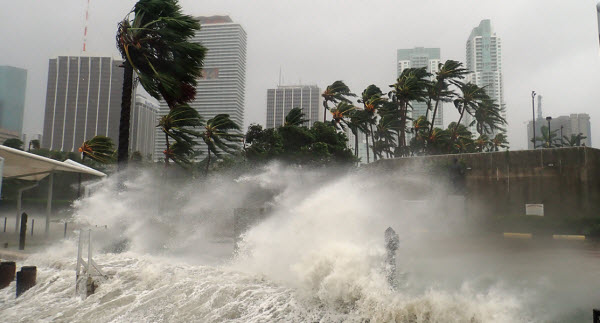
Storm surges are among the most dangerous phenomena associated with tropical cyclones, particularly in coastal areas. Surge heights can reach up to 6 meters in severe cyclones, primarily due to friction between strong winds and the ocean surface, leading to water accumulation in the direction of the winds. In the Northern Hemisphere, the effect is most pronounced in the storm’s right front quadrant, where winds are stronger. In the Southern Hemisphere, it occurs in the left front quadrant. The resulting sea-level rise causes flooding, which is often responsible for the majority of cyclone-related fatalities.
Rainfall
Tropical cyclones typically bring substantial rainfall to affected regions, with significant amounts coming from the deep convective clouds in the eye wall and rain bands. Rainfall rates can reach several centimeters per hour, leading to severe flooding, especially in low-lying areas such as Bangladesh and the Gulf Coast of the United States.
Cyclone Assessment
Intensity Scales
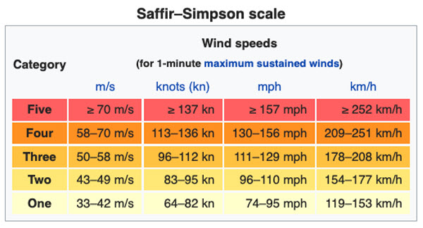
Cyclones exhibit a wide range of wind speeds, from mild to highly destructive. To assist in issuing warnings and indicating potential threat levels, numerical classification systems based on maximum wind speeds and storm surge potential have been developed. In the Atlantic and Eastern Pacific, the Saffir-Simpson Hurricane Wind Scale categorizes cyclones based on their strength. A similar scale is used for storms near Australia. Despite differences in starting points, the highest category in each scale is Category 5. Other ocean basins do not use numerical scales.
Naming System
Cyclones are named according to regional systems established by committees under the World Meteorological Organization. Each region maintains its own list of names, and changes (such as name retirements) are approved at official meetings. For example, in the North Atlantic, cyclone names are recycled every six years, with storm names from 2003 reused in 2009, and names from 2004 in 2010, excluding names of severe or catastrophic storms like “Mitch” and “Ivan.” In the Pacific and Indian Oceans, regional naming systems are used, while some areas, like the North Indian Ocean, use numbers instead of names.
Tracking and Forecasting
In the early 20th century, cyclone detection relied on weather changes, sea surface conditions, and reports from affected areas, which provided limited warning time and contributed to high fatality rates. Advances in satellite technology since the 1960s have significantly improved early detection and tracking of cyclones, providing continuous imagery in visible and infrared wavelengths. These images help track cyclone development by showing cloud top temperatures and are crucial for estimating storm intensity.
Detailed information on cyclone strength and structure is obtained directly using aircraft, primarily by the U.S., for storms impacting continental landmasses. This is due to the high costs associated with maintaining research aircraft, and other countries may not have the resources for such operations. When aircraft data are not available, satellite estimates of wind speeds and pressures are used.
