The Amazon River is one of the largest rivers in the world and a vital artery for the planet’s most extensive ecosystem. Stretching across much of South America, it is home to a vast array of flora and fauna that thrive in its lush, evergreen environment. It is also one of the world’s most voluminous rivers, with a flow that is six times greater than the combined flow of the next six largest rivers. The Amazon boasts the largest drainage basin globally due to its immense size, extending over 6,400 kilometers, making it the second-longest river in the world after the Nile in Africa. European explorers first charted the river in the 16th century, using it for transport and trade via boats and steamships. In recent years, Brazil has strived to protect the Amazon Basin from foreign exploitation, aiming to ensure its resources benefit its citizens. Today, the river faces environmental threats due to deforestation and a lack of public understanding regarding the significance of this remote region to human life.
Geographical Features of the Amazon River
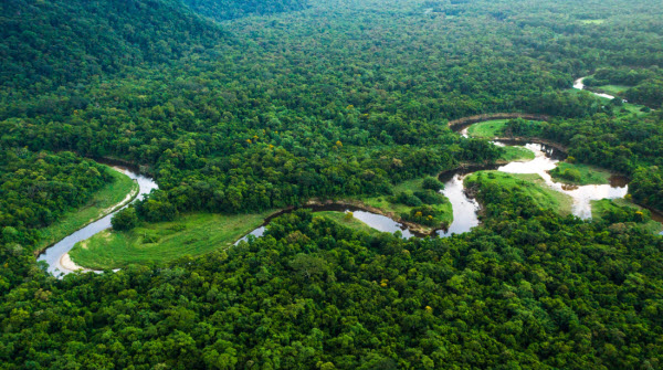
During the rainy season, the Amazon River and its tributaries cover surrounding areas with water up to three times the amount present during the dry season. While the river inundates 110,000 square kilometers of land during the dry season, it expands to 350,000 square kilometers during the rainy season. At its widest point, the Amazon can reach up to 11 kilometers across during the dry season, but during the rainy season, when it floods the surrounding plains, its width can increase to 40 kilometers. The amount of freshwater discharged into the Atlantic Ocean by the Amazon is immense, reaching 300,000 cubic meters per second during the rainy season. This represents one-fifth of the total volume of freshwater entering the world’s oceans, significantly reducing salinity up to 160 kilometers into the sea.
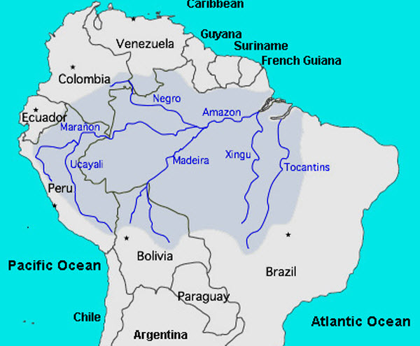
The Amazon River’s mouth is over 325 kilometers wide, and the main river, ranging from 1.6 to 10 kilometers in width, is navigable by large steamships in Brazil. Small ocean vessels can travel through it to Peru, approximately 3,600 kilometers from the sea. The river drains an area of about 7 million square kilometers, nearly 40 percent of South America, and its waters flow from 5 degrees north latitude to 20 degrees south latitude. Its most distant sources are in a snow-capped plateau between the Andes mountains, a short distance from the Pacific Ocean. After meandering through Peru and Brazil, it empties into the Atlantic Ocean at the equator.
Source and Upper Amazon
The upper Amazon River consists of a series of major river systems in Peru that flow north and south into the Marañón River. These rivers include Morona, Pastaza, Napo, Yuruani, Chambira, Tigre, Nanay, and Ucayali, originating in the snow-capped Andes mountains above Lake Llauriucacha in central Peru. The Marañón River flows through waterfalls and valleys in a high jungle region known as the “Bongos” and travels 1,600 kilometers from west-central to northeastern Peru before merging with the Ucayali River below the town of Nauta to form a major tributary of the Amazon.
Explorations have confirmed that the farthest source of the Amazon region is the snow-capped peak of Nevado Mismi, standing at 5,597 meters in the Andes mountains in Peru, about 160 kilometers west of Lake Titicaca and 700 kilometers southeast of Lima. From this peak, water flows into the Río Apurímac, a tributary of the Ucayali, which later merges with the Marañón to form the Amazon River, sometimes referred to as the Solimões River at the tri-border area of Peru, Colombia, and Brazil. At the confluence of the Apurímac and Ucayali rivers, the river shifts from Andean terrain to a floodplain, with only a few hills interrupting its lower banks before entering the vast Amazon rainforest.
The river systems and floodplains in the six countries bordering the Amazon — Brazil, Peru, Ecuador, Colombia, Venezuela, and Bolivia — that feed into the Solimões and its tributaries are referred to as the upper Amazon region.
Towards the Sea
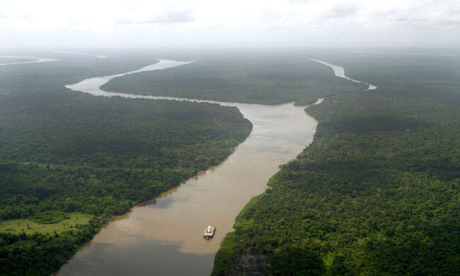
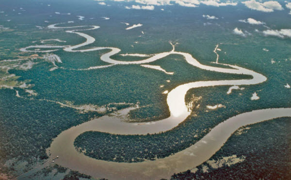
In some areas, the Amazon River is six to ten kilometers wide, splitting into two main channels with internal and lateral channels all connected by a complex system of natural waterways. At the Pará-Ovideus Strait, 600 kilometers from the sea, the river narrows to a single channel 1.6 kilometers wide with a depth of over 60 meters. Water flows towards the sea at speeds ranging from 6 to 8 kilometers per hour. From the village of Canarã at the great bend of the Amazon rainforest to Negro, 1,000 kilometers downstream, only very low-lying areas similar to those at the river’s mouth are found. These are vast expanses of land covered by high water, with only the tops of forest trees visible. In the lower reaches of the river, the northern bank is composed of a series of steep hills.
The Mouth of the River
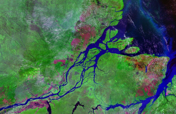
The mouth of the Amazon River is typically measured from Cabo do Norte to Ponto Patijoca, a distance of approximately 330 kilometers. This measurement includes the 60-kilometer-wide ocean outlet of the Pará River and the oceanfront of Marajó Island, which is roughly the size of Denmark, located at the mouth of the Amazon.
Just north of Cabo do Norte and 160 kilometers along the Guyana margin of the upper Amazon, there is a belt of semi-submerged islands and shallow sandy beaches where a tidal phenomenon known as the tidal bore occurs. The depths here do not exceed 7 meters, preventing the formation of a delta as the ocean’s currents prevent the accumulation of the massive sediment load carried by the Amazon, making delta growth impossible.
Amazon Rainforest and Wildlife
Starting from the eastern Andes, the Amazon rainforest, the largest tropical rainforest in the world, begins. It plays a crucial ecological role, capable of absorbing enormous amounts of carbon dioxide, making rainforest conservation a global priority.
The biodiversity within the rainforest is extraordinary. The region is home to at least 2.5 million insect species, tens of thousands of plants, and around 2,000 species of birds and mammals. One-fifth of all bird species in the world can be found in the Amazon rainforest. The plant diversity in the Amazon Basin is the highest on Earth, with some experts estimating that one square kilometer may contain over 75,000 tree species and 150,000 species of higher plants. A single square kilometer of Amazon rainforest can hold about 90,000 tons of living plants.
In addition to plant life, the Amazon River supports a wide variety of unique wildlife. Along with the Orinoco River, the Amazon is one of the primary habitats for the Amazon river dolphin, the largest of the river dolphins, which can grow up to 2.6 meters in length. The notorious piranha, known for its carnivorous feeding habits, is also found in large numbers, although experts believe their fearsome reputation is exaggerated. Few of these fish attack humans, with many feeding primarily on other fish. The Amazon Basin is also home to the anaconda, one of the world’s largest snake species, which spends most of its time in the water, emerging only its nostrils. It is known to occasionally attack hunters. Additionally, the river supports thousands of fish and turtle species.
History of the Amazon River
Before the European conquest of South America, the Amazon River did not have a single name. Instead, indigenous peoples had names for various parts of the river they inhabited, such as Paranaguaçu, Guayama, and Solimões. In 1500, Vicente Yáñez Pinzón, leading a Spanish expedition, was the first European to explore the river from its mouth, discovering that the ocean off the coast was fresh water. He named the river “Río Santa María de la Mar Dulce,” which was soon abbreviated to “Mar Dulce.” For several years after 1502, the river was known as the “Río Grande.” The name Amazon emerged after Francisco de Orellana’s battle with the Tabuyas tribe, where women fought alongside men, reminiscent of the Amazons of ancient Asia and Africa described by Herodotus and Diodorus. Orellana was also the first European to navigate from the Amazon region, beginning in the Andes in 1541 and reaching the Atlantic Ocean. Portuguese explorer Pedro Teixeira made the first ascent of the river in 1638, traveling against Orellana’s route to Quito via the Napo River.
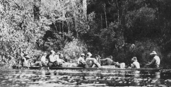
For 350 years after Pinzón’s discovery, the Portuguese part of the Amazon Basin remained a wilderness occupied by indigenous peoples. In what are now Brazil, Ecuador, Bolivia, Colombia, Peru, and Venezuela, colonial and missionary settlements were established along riverbanks and primary tributaries for trade, slavery, and missionary work among the indigenous people living in the vast rainforest. By 1850, the Brazilian portion of the Amazon Basin had a population of around 300,000, with approximately two-thirds being Europeans and around 25,000 slaves. That year, Emperor Dom Pedro II approved a law allowing steam navigation on the Amazon River, initially limited to the main river by the Amazonas Company. Eventually, navigation extended to several tributaries, attracting attention to the economic opportunities in the region. Other companies began to compete with Amazonas, which expanded its fleet. At the same time, private individuals started building and operating small steam boats on the main river and its tributaries.
By late July 1867, the Brazilian government, under pressure from neighboring countries like Peru, issued a decree opening the Amazon to navigation by all countries but restricted it to certain points. By the early 20th century, the main exports from the Amazon Basin included rubber, cocoa, and Brazil nuts, with
significant trade centered on the port of Manaus. In the 20th century, the Amazon River and its tributaries served as vital transportation links, playing a critical role in the economic development of the region. Despite the challenges posed by modernity and environmental threats, the Amazon River remains a symbol of natural beauty and ecological significance.
