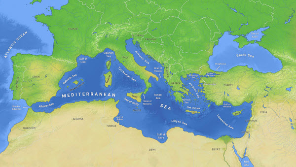
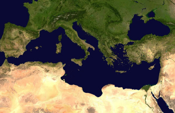
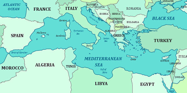
The Mediterranean Sea is one of the most strategically significant and historically rich bodies of water in the world. Covering an area of approximately 2.5 million square kilometers, it is bordered almost entirely by Europe to the north, Asia to the east, and Africa to the south. The Mediterranean is connected to the Atlantic Ocean via the narrow Strait of Gibraltar, which is only 13 kilometers wide and 320 meters deep. It also links to several other seas, such as the Black Sea through the Dardanelles and the Sea of Marmara, often considered part of the Mediterranean, via the Bosporus Strait. Additionally, it connects to the Red Sea in the southeast through the Suez Canal. Historically, the warm and temperate climate of the Mediterranean region has fostered the development of many ancient civilizations, including the Greek and Roman empires in the north and the Egyptian and Carthaginian civilizations in the south. This strategic waterway has been crucial for trade and cultural exchange, making an understanding of its history vital for comprehending the origins and development of many modern societies.
Climate and Geography
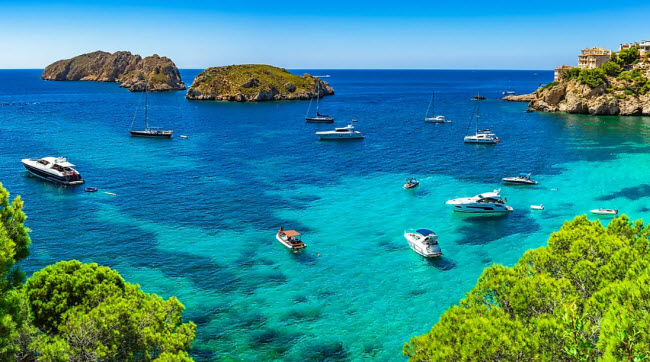
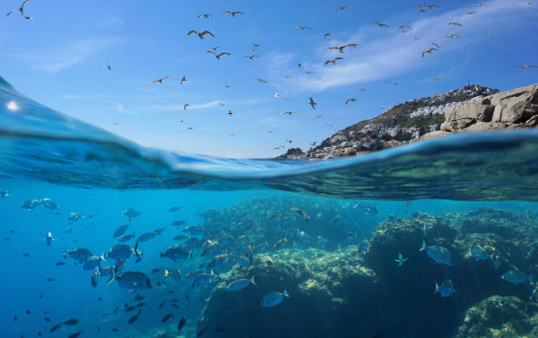
The Mediterranean climate is characterized by wet, mild winters and hot, dry summers. The sea contains numerous islands, notable among them Cyprus, Crete, Rhodes, and Lesbos in the east; Sardinia, Corsica, Sicily, and Malta in the central region; and Ibiza, Mallorca, and Menorca in the west. The Mediterranean’s nature as a semi-enclosed sea is evident in its limited tidal range due to its narrow connection with the Atlantic Ocean. Its deep blue color, particularly around the Greek islands, and sensitivity to climatic changes are notable features. During dry periods, dust from the Sahara Desert can deposit in the Mediterranean, while wet periods see an influx of riverine sediments.
The Mediterranean’s rate of evaporation exceeds its precipitation, affecting water movement within the sea. The amount of freshwater flowing into it from rivers is only a third of the water lost through evaporation, which is especially high in the eastern Mediterranean. This imbalance leads to lower water levels and increased salinity towards the east. Consequently, relatively cooler, lower-salinity water from the Atlantic Ocean enters the Mediterranean, warms up, and becomes more saline as it moves eastward. Surface salinity averages about 38 parts per thousand, except near the Atlantic, where it approaches 40 parts per thousand in the eastern Mediterranean during summer. Deep water salinity averages around 38.4 parts per thousand.
The Mediterranean Sea has three main water layers: the surface layer, the intermediate layer, and the deep layer at the bottom. Its waters circulate in a counterclockwise direction, with the regions closer to the equator experiencing warmer temperatures. For example, the Gulf of Sidra off the Libyan coast records the highest water temperatures, reaching around 31°C in August, followed by the Gulf of Iskenderun at 30°C. In contrast, the coldest surface temperatures occur in the northern Adriatic Sea, where February temperatures can drop to 5°C in the Gulf of Trieste, occasionally forming ice in winter.
Geological Features
The Mediterranean Sea’s geology is complex, involving the breakup and subsequent collision of the African and Eurasian tectonic plates. The average depth of the Mediterranean is 1,500 meters, with the deepest point recorded at 5,267 meters in the Calypso Deep in the Ionian Sea. Its coastline stretches 46,000 kilometers and features a series of shallow underwater ridges under the Strait of Sicily, separating Sicily from the Tunisian coast and dividing the sea into two main sub-regions: the Western Mediterranean, covering 850,000 square kilometers, and the Eastern Mediterranean, spanning 1.65 million square kilometers.
Countries and Territories
The Mediterranean Sea is bordered by 21 countries:
- Europe (from west to east): Spain, France, Monaco, Italy, Malta, Slovenia, Croatia, Bosnia and Herzegovina, Montenegro, Albania, Greece.
- Asia (from north to south): Turkey, Syria, Cyprus, Lebanon, Palestine.
- Africa (from east to west): Egypt, Libya, Tunisia, Algeria, Morocco.
Additionally, several regions bordering the Mediterranean include:
- The British Overseas Territory of Gibraltar.
- Ceuta and Melilla and the surrounding islands (Spain).
- Mount Athos (Greece).
- The Sovereign Base Areas of Akrotiri and Dhekelia (Cyprus).
Countries like Macedonia, Portugal, San Marino, Serbia, and Vatican City, although not directly bordering the sea, are often considered Mediterranean in a broader sense due to their Mediterranean climates, flora, fauna, and cultural proximity to other Mediterranean nations.
Smaller Seas and Bays
The Mediterranean is subdivided into several smaller seas, each with its own designation:
- The Alboran Sea between Spain and Morocco.
- The Balearic Sea between the Spanish mainland and the Balearic Islands.
- The Ligurian Sea between Corsica and Liguria (Italy).
- The Tyrrhenian Sea surrounded by Sardinia, the Italian Peninsula, and Sicily.
- The Adriatic Sea between the Italian Peninsula and the coasts of Slovenia, Croatia, Bosnia and Herzegovina, Montenegro, and Albania.
- The Ionian Sea between Italy, Greece, and Albania.
- The Aegean Sea between Greece and Turkey, with the Thracian Sea to its north.
- The Minoan Sea between the Cyclades and the Peloponnesus.
- The Cretan Sea north of Crete.
- The Libyan Sea south of Crete, between the island and Libya.
- The Marmara Sea between the Aegean and the Black Sea.
- The Cilician Sea between Turkey and Cyprus.
The Mediterranean also contains numerous bays, including:
- The Bay of Saint George in Lebanon.
- The Gulf of Corinth, a closed sea between the Ionian Sea and the Corinth Canal.
- The Saronic Gulf and Athens Gulf, between the Corinth Canal and the Minoan Sea.
- The Gulf of Thessaloniki in northern Greek Macedonia.
- The Bay of Kvarner in Croatia.
- The Bay of Hyères in southern France.
- The Bay of Valencia in eastern Spain.
- The Strait of Messina between Sicily and the Italian mainland.
- The Gulf of Taranto in southern Italy.
- The Strait of Otranto between Italy and Albania.
- The Bay of Haifa between Haifa and Acre in Palestine.
- The Gulf of Sidra between Tunisia and Cyrenaica (eastern Libya).
- The Strait of Sicily between Sicily and Tunisia.
- The Corsican Canal between Corsica and Italy.
- The Strait of Bonifacio between Sardinia and Corsica.
- The Gulf of Iskenderun between Iskenderun and Adana (Turkey).
- The Gulf of Antalya on Turkey’s western and eastern coasts.
- The Bay of Kotor on the Montenegrin coast.
Environmental Challenges
The Mediterranean Sea faces several environmental challenges. During the Messinian salinity crisis, the region experienced significant desiccation, leading to the extinction of much marine life. Today, the sea’s marine flora is primarily derived from the Atlantic Ocean. In recent centuries, human activity has altered the Mediterranean’s geology through canal construction, river diversion, and coastal development, exacerbating erosion patterns. Historically, seasonal flows from the Nile River helped reduce coastal salinity, affecting fishery productivity in the southeastern Mediterranean until the construction of the Aswan High Dam in 1970 stabilized the Nile’s seasonal discharge into the Mediterranean.
Additional issues include poor coastal management, overexploitation of natural and marine resources, industrial and chemical pollution from ships, and raw sewage discharge, which exceeds one million tons annually. These factors have led to the near disappearance of several marine species, such as the Mediterranean monk seal.
