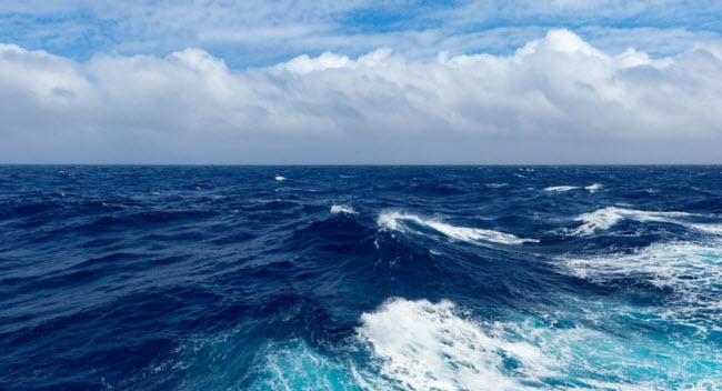
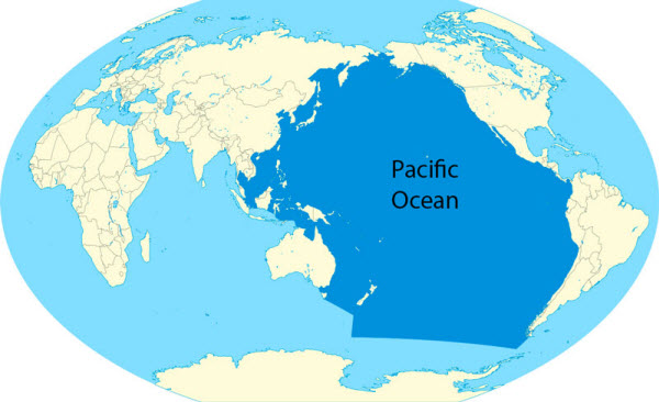
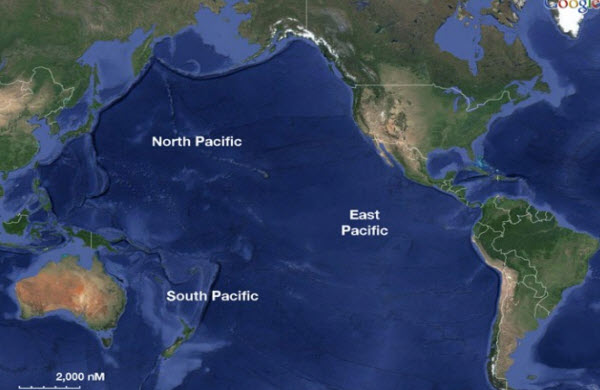
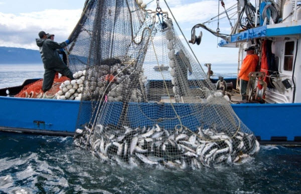
The Pacific Ocean is the largest of Earth’s oceanic divisions, containing about 46% of the planet’s total water and covering approximately 32% of its total surface area. It stretches from the Arctic Ocean in the north to the Antarctic in the south. To the east, its boundaries extend from Asia to Australia, while to the west, it is bordered by the Americas. The Portuguese explorer Ferdinand Magellan was the first to name it, attributing the term “Pacific” to the relatively calm nature of its waters. The Pacific Ocean spans between 165.2 to 181.3 million square kilometers, making it twice the size of the Atlantic Ocean and larger than the total landmass of Earth. Its average depth is 4280 meters, and it contains the deepest point on the Earth’s surface, the Mariana Trench. This ocean serves as a crucial link between the East and West culturally, commercially, and politically, and is a vital source of marine food for the countries bordering it, providing a significant fishery resource. Fishing activities in the Pacific represent three-fifths of the world’s total marine catch.
Historical Exploration of the Pacific Ocean
Early Exploration
Significant human migrations occurred across the Pacific Ocean during prehistoric times. Notable among these were the Polynesians, who migrated from the Asian edge of the ocean to Tahiti, Hawaii, and New Zealand, and much later to Easter Island. Early settlers also reached Melanesia, gradually moving north to Micronesia and east to Polynesia. These voyages were evidently carried out using large sailing vessels, beginning between 3000 and 4000 years ago and continuing until the Māori settled in New Zealand about 1000 years ago.
European Exploration
European exploration of the Pacific Ocean in the 16th century can be divided into three phases: Spanish and Portuguese, Dutch, and English and French.
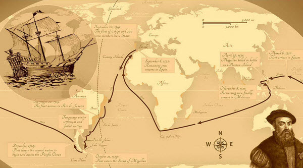
- Spanish and Portuguese Phase: The Pacific Ocean was first seen by Europeans in the early 16th century when Spanish explorer Vasco Núñez de Balboa crossed the Isthmus of Panama from the Caribbean to the Pacific Ocean in 1513. Ferdinand Magellan’s expedition (1519-1522), after spending three months and twenty days navigating the stormy straits at the southern tip of South America, reached the Mariana Islands in March 1521. Subsequently, García Jofré de Loaísa’s expedition (1525-1527) crossed the southern Pacific from east to west, briefly establishing a Spanish colony in Tidore and studying winds and currents, demonstrating how to travel from west to east by sailing north from the Philippines to Japan. This route became a major trading path until British and French maritime explorations in the late 18th century. In 1564, explorers led by Miguel López de Legazpi crossed the Pacific from Mexico to the Philippines and the Mariana Islands in six ships. In 1567, Álvaro de Mendaña de Neira sailed west from Callao in Peru to western Melanesia. During the remainder of the 16th century, Spanish influence was significant, with ships sailing from Spain to the Philippines, New Guinea, and the Solomon Islands, and exploring the southwestern Pacific, discovering the Bismarck Archipelago and Vanuatu.
- Dutch Phase: During the 17th century, Dutch explorers, who had dominated exploration and trade, left five ships from the Netherlands to the Pacific via the Magellan Strait in 1598. However, some were seized by the Portuguese, Spanish, and Japanese, and others were lost at sea, with only one ship returning in 1600 with just 36 of the original 491 crew members. In 1616, the Dutch ship “Endracht,” under Jacob Le Maire and Willem Schouten, found a new route into the Pacific besides the Magellan Strait. While sailing west, the Dutch encountered the inhabitants of the Tuamotus, Tonga, and New Guinea. In 1642, Dutch explorer Abel Tasman became the first European to enter the southern Pacific from the west, sailing completely around Australia and visiting Tasmania, New Zealand, Tonga, and Fiji. In 1721, Jacob Roggeveen, in search of a great southern continent, landed on Easter Island on Easter Sunday 1722, describing its tattooed inhabitants and large stone statues.
- English and French Phase: The 18th century saw a surge of explorers from Russia to Alaska and the Aleutian Islands, French explorers in Polynesia, and British expeditions, notably those by James Cook, who made three voyages: to the South Pacific, Australia, Hawaii, and the northwest Pacific in North America. During his first voyage to Tahiti, Cook discovered several islands, surveyed the coasts of New Zealand and eastern Australia. On his second voyage, he mapped Tonga and Easter Island and discovered New Caledonia. His third voyage included exploring the northern Pacific, the Bering Strait, and his maps and charts were so accurate that they were not revised or corrected. English explorers John Byron, Samuel Wallis, and Philip Carteret made significant discoveries, with Byron exploring the northern Mariana Islands and discovering islands in the Tuamotu Archipelago and the Cook Islands. Wallis discovered islands in the Tahitian group, and Carteret saw Pitcairn Island and explored the southern Pacific. French explorer Louis Antoine de Bougainville sailed to Tahiti, Samoa, Vanuatu, New Guinea, and the Solomon Islands.
Geology of the Pacific Ocean
The floor of the Pacific Ocean is composed of two main regions characterized by different types of rocks. The first is the Central Pacific Basin, distinguished by submerged volcanic rocks, while the second is the submerged continental margins, characterized by metallic volcanic rocks. Geologists define the narrow transition zone between these regions as the “Andesite Line,” which runs along the western edge of the islands off California in the United States, south of the Aleutian Arc, along the eastern edge of the Kamchatka Peninsula, the Kuril Islands, Japan, the Mariana Islands, the Solomon Islands, and New Zealand. The Andesite Line continues in a northeast direction along the western edge of the Andes Mountains in South America, then into Mexico and back to the islands off California. Indonesia, the Philippines, Japan, New Guinea, New Zealand, and all eastern extensions of the continental masses of Australia and Asia lie outside the Andesite Line.
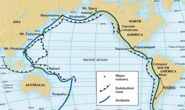
Within the closed ring of the Andesite Line lie most of the deep basins, submerged volcanic mountains, and oceanic volcanic islands that characterize the Pacific Basin. In these areas, basaltic lava flows gently from fissures, building massive dome-shaped volcanic mountains, whose eroded peaks form island arcs. Outside the Andesite Line are explosive volcanoes, with the Pacific Ring of Fire being the world’s primary zone for explosive volcanism. The numerous equatorial islands in the Pacific Ocean are primarily coral-based.
Landmasses in the Pacific Ocean
New Guinea is the largest landmass entirely within the Pacific Ocean and the second-largest island in the world. Most small Pacific islands are located between 30 degrees north and 30 degrees south latitude, extending from Southeast Asia to Easter Island. The remaining part of the Pacific Basin is almost entirely submerged. North of the equator and west of the Greenwich Meridian, there are many small islands in Micronesia, including the Caroline Islands, the Marshall Islands, and the Mariana Islands, most of which are coral-based. In the southwestern corner of the Pacific Ocean are the coral islands of Melanesia, dominated by New Guinea, which includes other significant Melanesian island groups such as the Bismarck Archipelago, Fiji, New Caledonia, the Solomon Islands, and Vanuatu.
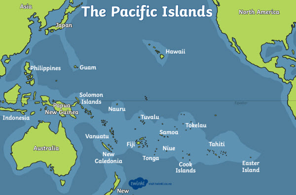
Pacific islands can be categorized into four main types: continental islands, high islands, coral reefs, and raised coral reefs. Continental islands, such as New Guinea, New Zealand, and the Philippines, are structurally linked to nearby continents. High islands are of volcanic origin, many with active volcanoes, including Bougainville, Hawaii, and the Solomon Islands. Coral reefs and raised coral reefs result from the buildup of coral islands over basaltic lava flows beneath the ocean’s surface. The most famous is the Great Barrier Reef off northeastern Australia.
Characteristics of the Pacific Ocean
Surface currents in the Pacific Ocean generally flow clockwise in the Northern Hemisphere and counterclockwise in the Southern Hemisphere.
Salinity
Water temperatures in the Pacific Ocean range from freezing in polar regions to about 25-30°C near the equator. Generally, it is warmer than the Atlantic Ocean. Salinity varies with latitude; tropical rainfall, variable winds near the equator, and cloudy skies that reduce evaporation contribute to lower salinity in equatorial regions compared to mid-latitudes, where salinity can reach 34 parts per thousand. Salinity is also lower near the poles due to minimal evaporation in these frozen areas.
In the open Pacific Ocean, surface salinity is highest at 37 parts per thousand, particularly in the southeastern region in the northern trade wind belts. Salinity decreases near the Antarctic continent to below 34 parts per thousand and less than 32 parts per thousand in the extreme northern regions. In the western Pacific, heavy rainfall associated with regional monsoon winds keeps salinity relatively low.
Climate
In summer, the heating of air masses over tropical Asia triggers a low-pressure system associated with rain-bearing winds, known as the monsoons. This low-pressure system becomes the focal point for trade winds in both hemispheres. In winter, cooling of the continent develops the Asian high-pressure system, enhancing trade winds in the Northern Hemisphere. Generally, the weather in the trade wind belts is good, but off the western coasts of the Americas, upwelling of cold subsurface waters cools the air above the dew point, leading to widespread low cloud formation and fog.
Political and Economic Aspects of the Pacific Ocean
Political
Seventeen independent countries are located in the Pacific Ocean. The islands are divided into three main regions: Melanesia, Micronesia, and Polynesia, each with diverse political structures. Some regions are organized as dependencies of other countries. For example, New Caledonia is a French overseas territory, while the Cook Islands and Niue are self-governing territories in free association with New Zealand.
Economic
The Pacific Ocean plays a vital role in global trade and commerce, with major shipping routes passing through it, connecting Asia, Australia, and the Americas. It is also rich in marine resources, including fisheries, minerals, and oil. The region is known for its tuna fisheries, which are crucial for the economies of many Pacific island nations.
Cultural and Social Aspects
The Pacific Ocean has greatly influenced the cultures and societies of the countries and islands that border it. From ancient navigators to modern tourism, the ocean has shaped the way people live, trade, and interact with one another. Festivals, traditions, and daily life in many Pacific communities are closely tied to the ocean and its resources.
