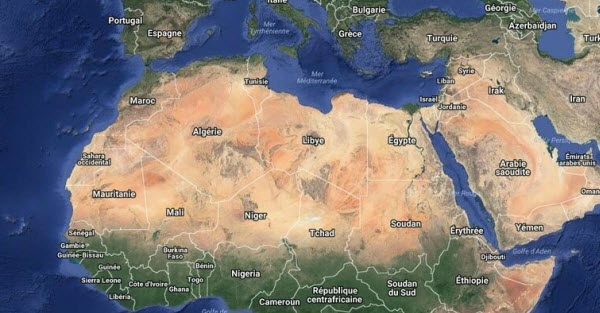
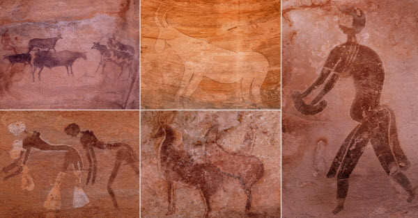
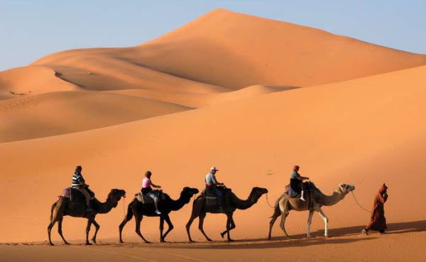
The Sahara Desert is a vast, arid region located in North Africa. It is the largest hot desert in the world and the second largest desert overall, after the Antarctic Desert, covering an area exceeding 9 million square kilometers, which is roughly equivalent to the size of the United States. Due to its immense size, it stretches across the borders of 10 countries. Although much of its expanse is uninhabited, approximately two million people live within its boundaries, excluding those residing along the Nile and Niger rivers. Despite the harsh conditions today, the Sahara was much more humid in ancient times, following the last Ice Age. Thousands of rock engravings discovered in the Tassili n’Ajjer Caves in southeastern Algeria depict life that once thrived in the area. Dinosaur fossils have also been found, indicating significant changes that led to the loss of vegetation, with the exception of the Nile Valley and a few oases.
Geographical Boundaries
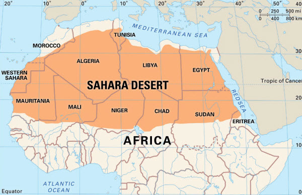
The Sahara Desert is bordered by the Atlantic Ocean to the west, the Atlas Mountains and the Mediterranean Sea to the north, Egypt and the Red Sea to the east, and Sudan and the Niger River Valley to the south. The desert divides the continent into North Africa and Sub-Saharan Africa, with its northern boundary characterized by semi-arid savannas known as the Sahel. The highest point in the Sahara is the summit of Mount Koussi in the Tibesti Mountains, which reaches an elevation of 3,415 meters, while the lowest point is in the Qattara Depression in Egypt, lying 133 meters below sea level.
Regions of the Sahara Desert
Although the Sahara spans across the entire continent and borders ten countries—Egypt, Sudan, Libya, Algeria, Morocco, Mauritania, Mali, Niger, Tunisia, and Chad—it can be divided into distinct regions:
- Western Sahara: This area consists of vast plateaus in Morocco extending to the foothills of the Atlas Mountains. It lacks surface water but contains dry riverbeds (wadis) that retain water only during rare rains. When underground rivers from the mountains surface, they create small oases. The region is rich in minerals such as phosphate, iron, zinc, and gold.
- Grand Erg Occidental and Grand Erg Oriental: These are vast, uninhabited regions in Algeria made up mostly of sand dunes shaped into peaks and ridges by the wind. A rocky plateau separates the two areas, with extremely low rainfall.
- Tanezrouft Desert: A rocky desert in southern central Algeria, known as the “Land of Terror” due to its lack of water. It is characterized by deep ravines.
- Tassili n’Ajjer: A very dry mountainous region in southern Algeria that once had lakes fed by mountain streams. Winds have eroded many rock formations, and ancient cypress and wild olive trees grow on its heights. The area contains cave paintings dating back 6,000 to 7,000 years. Today, the Tuareg tribes cultivate crops around the valleys and oases.
- Hoggar Desert: A largely uninhabited mountainous area in Algeria known for its volcanic rock formations. The mountains contain caves with ancient paintings depicting cattle, rhinoceroses, elephants, giraffes, and hyenas.
- Libyan Desert: This region consists of rocky plateaus and sandy plains extending from eastern Libya to northwestern Sudan. It has several oases where grains, olives, grapes, and dates are cultivated.
- Fezzan Desert: A vast expanse of sandstone and limestone forming natural arches and caves in southwestern Libya. It is famous for its prehistoric rock art and fossils.
- Western and Eastern Deserts: The Western Desert covers two-thirds of Egypt and merges with the Libyan Desert, featuring depressions below sea level and several large oases, the largest being Siwa, surrounded by olive farms. The Eastern Desert lies between the Suez Canal and the Red Sea, inhabited by Bedouins who raise sheep, camels, and goats.
- Tibesti Mountains: Formed during volcanic eruptions about seventy million years ago, these mountains in Chad contain many prehistoric rock carvings and were the site of the discovery of the Australopithecus species known as “habilis.”
- Ténéré Desert: The southernmost branch of the Sahara, located in Niger, is filled with undulating sand dunes, the most famous being the Erg of Bilma. Despite its current lack of vegetation, with only a few oases that once formed the backbone of caravan routes, the desert has rock art depicting animals and fossilized tree trunks, indicating wetter times in the ancient past.
- Air Massif: A granite massif in central Niger with sides carved by long-ago flowing currents. Agriculture occurs around larger oases, and Agadez, the largest settlement in the region, is located on the southern slopes of the massif.
Climate of the Sahara Desert
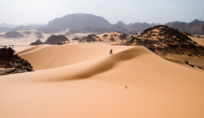
The Sahara Desert has experienced significant climatic fluctuations between wet and dry periods over the past hundreds of thousands of years. During the last Ice Age, it was larger and extended further south than it does today. The end of the Ice Age brought wet periods to the Sahara from around 8000 to 6000 BCE, possibly due to low-pressure areas over the collapsing ice sheets in the north. Once these disappeared, the northern part of the desert dried up, and by 2500 BCE, the desertification process had begun, making it as arid as it is today. The Sahara now features one of the harshest climates globally, with strong winds blowing from the northeast and occasionally from the north and south borders. It receives about 25 cm of rain annually, with heavy rainfall following long dry periods that can last for years. Daytime temperatures can reach 58°C, while nighttime temperatures can drop to -6°C.
Historical Context
According to archaeologists, the Sahara was more densely populated over twenty thousand years ago when its climate was not as dry. Fossils, rock art, stone artifacts, bone harpoons, and shells have been found in areas that are now extremely hot and dry. Additionally, artifacts and animal remains such as giraffes, elephants, buffalo, antelope, rhinoceroses, fish, crocodiles, and hippopotamuses indicate the presence of lakes and wetlands in the desert. Between twenty and twelve thousand years ago, harsh conditions returned, leaving the desert largely uninhabited except for highland areas with springs and surface ponds fed by groundwater. Around ten thousand years ago, fruit gatherers and hunters reoccupied the lakes, streams, and wetlands that had been rejuvenated. Evidence of possible agriculture dates back eight thousand years, with further evidence of livestock farming in the mountains seven thousand years ago. These populations eventually left three to four thousand years ago due to deteriorating conditions, leaving only scattered settlements around oases, with the Nile Valley being a significant exception.
By 6000 BCE, pre-dynastic Egyptians were living in the southwestern part of Egypt, herding livestock, building large structures, and living in organized and permanent settlements based on grain cultivation and animal husbandry. The Phoenicians later established a confederation of kingdoms across the Sahara, settling mostly along the coasts and occasionally within the desert. The first desert crossings were made around 1000 BCE by oxen and horses, though travel was rare until the third century CE when domesticated camels were introduced. By 500 BCE, Greek influence spread as Greek traders established colonies along the eastern Sahara coast and the Red Sea. Carthaginians explored the Atlantic coast, but central powers surrounded the desert from the north and east, leaving the desert itself largely unconquered.
In the heart of the Sahara, the Garamantian civilization emerged in a valley now called Wadi al-Ajal in Fezzan, Libya. The Garamantes dug tunnels into the surrounding mountains to access fossil water for their fields. They grew powerful and conquered neighboring regions, enslaving many for tunnel expansion. The Greeks and Romans considered them uncivilized nomads. Eventually, the civilization collapsed as they exhausted their groundwater supplies and could no longer maintain their expansion efforts.
Following the Arab conquest of the Sahara, trade intensified, and coastal kingdoms, notably the Ghana Empire and later the Mali Empire, grew wealthy from exporting gold and salt to North Africa. This trade continued for centuries, with colonial powers largely ignoring the region. In modern times, numerous mines and communities have developed to exploit the Sahara’s natural resources, including significant oil and natural gas reserves in Algeria and Libya, and large phosphate deposits in Morocco and Western Sahara. Today, approximately two million people live in the Sahara, leading either nomadic or settled lives wherever food and water are available, primarily in Egypt, Mauritania, Morocco, and Algeria. The dominant ethnic groups in the Sahara are various Berber groups, including Tuareg tribes and Arabized Amazigh groups like the Moroccan Hassani speakers, also known as Sahrawis, as well as various black African ethnic groups such as the Toubou, Nubians, Fulani, and Hausa.
The largest city in the Sahara is Cairo, Egypt’s capital, located in the Nile Valley. Other significant cities include Nouakchott, the capital of Mauritania, Algiers, and Timbuktu in Mali, among others.
Flora and Fauna
Despite the extreme aridity of the Sahara Desert, it is home to a variety of animals that have adapted to these harsh conditions. The region supports 70 mammal species, including 20 large mammals, 90 resident bird species, and around 100 reptile species. The wildlife includes antelopes, gazelles, jackals, hyenas, foxes, rodents, insects, scorpions, and ants. The mountains provide habitat for sheep, leopards, and the sand gazelle, which has flattened hooves to traverse the sand. Foxes in the desert have large ears to dissipate heat and hairy soles to prevent sand damage. The flora is sparse but includes hardy species such as cacti, shrubs, and hardy grasses. While vegetation is limited to oases and a few areas of low-lying plant life, these regions have evolved to support a variety of desert-adapted species.
The Sahara Desert continues to be a region of interest due to its unique environmental conditions, historical significance, and the adaptability of its flora and fauna.
